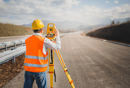
In any land development, construction, or environmental project, the accuracy of your foundational data can make or break the outcome. One of the most critical types of data you’ll rely on is the topographical land survey a detailed mapping of a site’s natural and man-made features, including elevations, contours, vegetation, and structures.
Choosing the right experts to conduct your topographical survey ensures you receive precise, reliable information that guides design, planning, and construction effectively. But with many surveying firms and professionals available, how do you make the best choice?
This article will guide you through the essential factors to consider when selecting experts for accurate topographical land surveys, helping you avoid costly mistakes and set your project on the path to success.


Why Accuracy Matters in Topographical Surveys
Topographical surveys are more than just maps. They provide a three-dimensional representation of the land’s surface, crucial for:
- Designing buildings, roads, and infrastructure
- Calculating earthworks and drainage
- Ensuring regulatory compliance and obtaining permits
- Managing environmental impact and sustainability
- Minimizing construction risks and unexpected costs
Errors or omissions in the survey data can lead to design flaws, regulatory issues, increased costs, and project delays. Therefore, accuracy is paramount, and that begins with hiring the right experts.
Key Factors in Choosing the Right Topographical Survey Experts
1. Professional Qualifications and Accreditation
Start by verifying the credentials of the surveyors or surveying firm. Look for professionals who hold relevant certifications or memberships with recognized industry bodies such as:
- Royal Institution of Chartered Surveyors (RICS)
- American Congress on Surveying and Mapping (ACSM)
- National Society of Professional Surveyors (NSPS)
- Local or national regulatory authorities
Accreditation ensures the surveyors adhere to industry standards, ethical guidelines, and best practices, which underpin the quality and accuracy of their work.
2. Experience Relevant to Your Project Type
Topographical surveying spans diverse sectors, from residential developments to large infrastructure projects, mining, agriculture, and environmental management. Experts familiar with your project type are better equipped to anticipate specific challenges and requirements.
Ask about their experience with:
- Similar land types and terrain complexity
- The scale and scope of projects they’ve handled
- Relevant regulatory environments and permitting processes
- Specialized survey types (e.g., 3D laser scanning, drone surveys)
This ensures their approach matches your project’s unique needs.
3. Technological Capability and Equipment
Modern surveying technologies significantly improve the speed and precision of topographical surveys. When evaluating surveyors, inquire about the tools and techniques they use:
- 3D Laser Scanning (LiDAR): Produces high-resolution, detailed 3D point clouds
- Drones (UAVs): For aerial photogrammetry and difficult-to-access areas
- Total Stations and GPS: For accurate ground measurements and control points
- Advanced Software: CAD, BIM, and GIS integration for detailed mapping and modeling
Surveyors investing in cutting-edge technology can provide richer data sets, reduce errors, and deliver results faster.
4. Scope of Services and Deliverables
Clarify what the survey includes and the format of deliverables. High-quality experts will provide:
- Detailed contour maps with accurate elevation data
- Plans showing natural and man-made features clearly annotated
- Digital files compatible with your design or engineering software (e.g., AutoCAD, Revit)
- Reports outlining methodology, accuracy, and any site observations
Ensure the deliverables meet your technical needs and can seamlessly integrate into your project workflow.
5. Quality Assurance and Accuracy Standards
Ask about their quality control processes. How do they ensure data accuracy and completeness? This might include:
- Field verification and repeated measurements
- Cross-checking with existing data or records
- Using redundant measurement techniques
- Independent review or certification of survey results
Transparent quality assurance builds confidence in the reliability of the survey.
6. Reputation and References
Research the firm’s or surveyor’s reputation. Look for:
- Client testimonials and case studies
- Online reviews and industry recognition
- Referrals from trusted professionals or colleagues
Don’t hesitate to request references and follow up to learn about their experiences, responsiveness, and professionalism.
7. Communication and Customer Service
Accurate surveys require close collaboration between surveyors and your project team. Choose experts who communicate clearly and promptly, explain technical aspects in understandable terms, and are willing to tailor their services to your project timeline and requirements.
Effective communication minimizes misunderstandings and helps resolve issues proactively.
8. Local Knowledge and Accessibility
Surveyors familiar with the local geography, regulations, and typical site challenges can offer advantages such as:
- Insight into local environmental conditions
- Experience with regional permitting and compliance requirements
- Faster response times for site visits and problem-solving
Local expertise often translates into smoother project execution.
9. Competitive and Transparent Pricing
While cost should never be the sole factor, it’s important to ensure pricing is fair, transparent, and aligned with the services offered.
Obtain detailed quotes outlining:
- What is included in the survey scope
- Any additional fees for complex or expanded work
- Payment terms and timelines
Avoid choosing the cheapest option if it compromises quality, as inaccuracies will cost more over time.
Questions to Ask Potential Surveyors
To make an informed choice, consider asking:
- What certifications and accreditations do you hold?
- Can you share examples of projects similar to mine?
- What technology and methods do you use for topographical surveys?
- How do you ensure the accuracy and completeness of your data?
- What deliverables will I receive, and in what formats?
- How do you handle unforeseen site challenges?
- Can you provide references or testimonials?
- What is your typical project turnaround time?
- How do you communicate progress and findings?
- What are your pricing structures and policies?
Final Thoughts
Choosing the right experts for your topographical land survey is a critical step that impacts every phase of your project, from initial design to construction and regulatory compliance. By prioritizing qualifications, experience, technology, and communication, you ensure you receive accurate, reliable data that supports smart decision-making.
Investing the time to select trusted, competent surveyors not only protects your project from costly errors and delays but also lays a strong foundation for success.